Provence-Alpes-Côte d'Azur Mountain Passes Atlas Map
Official regional cartographic atlas covering mountain passes across Hautes-Alpes (05), Alpes-de-Haute-Provence (04), Alpes-Maritimes (06), Var (83), and Vaucluse (84).
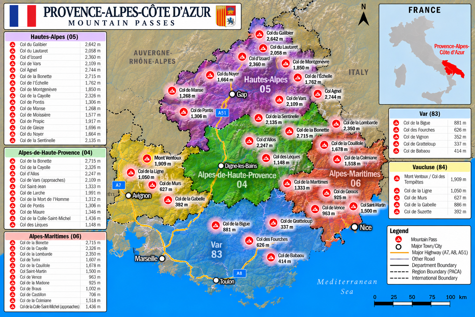
Pass Directory & Live Status
Col du Galibier
OPEN / SEASONALRoute D902 famous Tour de France summit connecting Lautaret with Valloire. Closed late Oct to late May.
Col du Lautaret
OPEN YEAR-ROUNDRoute D1091 strategic mountain highway pass linking Grenoble with Briançon. Kept open 365 days with rotary snowplows.
Col d'Izoard
OPEN TODAYRoute D902 iconic pass linking Briançon with Queyras. World-renowned for the Casse Déserte rock towers. Seasonal winter closure.
Col de Vars
OPEN YEAR-ROUNDRoute D902 arterial highway pass connecting Guillestre with the Ubaye Valley. Snowplows maintain open transit 365 days a year.
Col Agnel (Colle dell'Agnello)
OPEN TODAYRoute D205 third highest paved road pass in the Alps connecting Molines-en-Queyras with Pontechianale (Italy). Closed Nov to June.
Col de la Bonette
OPEN TODAYC4 / D64 highest paved through-road in France connecting Jausiers (Ubaye) with Saint-Étienne-de-Tinée. Closed Nov to June.
Col de l'Échelle
OPEN TODAYRoute D1T connecting Névache (Clarée Valley) with Bardonecchia (Italy). Lowest alpine pass linking northern and southern French Alps.
Col de Montgenèvre
OPEN YEAR-ROUNDNational Highway N94 primary international trunk corridor connecting Briançon with Cesana Torinese (Piedmont, Italy). Open 365 days.
Col de la Cayolle
OPEN TODAYRoute D902 pristine pass through Mercantour National Park linking Barcelonnette with Entraunes and Var river headwaters. Closed Nov–May.
Col de Pontis
OPEN TODAYRoute D7 scenic narrow mountain pass connecting Savines-le-Lac (Lake Serre-Ponçon) with the Ubaye Valley. Open year-round.
Col de Manse
OPEN YEAR-ROUNDRoute D944 pass linking Gap with Champsaur valley. Famous Tour de France descent into Gap. Open 365 days a year.
Col de Moissière
OPEN TODAYRoute D214 mountain pass connecting Ancelle with Saint-Jean-Saint-Nicolas in the Champsaur valley. Maintained open with winter gear.
Col de Prapic
TREKKING OPENHigh alpine gap pass near Orcières-Merlette and Prapic village at the gateway of Écrins National Park. Hiking trail pass.
Col de Gleize
OPEN TODAYRoute D504 pass above Gap / Laye connecting Gapençais with Champsaur. Scenic forest pass maintained open year-round.
Col du Noyer
OPEN TODAYRoute D17 spectacular cliffside road connecting Dévoluy massif with Champsaur valley. Closed during deep winter (Nov–May).
Col de la Sentinelle
OPEN YEAR-ROUNDRoute D11 mountain pass connecting Gap with Valserres and the Durance Valley. Classic Tour de France route open 365 days a year.
Pass Summary & Status Comparison Table
| Pass Name | Elevation | Dept / Region | Route Code | Winter Status Window | Winter Equipment Rule | Current Live Status |
|---|---|---|---|---|---|---|
| Col du Galibier | 2,642 m | Hautes-Alpes / Savoie | D902 | Closed Late Oct – Late May | Chains / Winter tires required | OPEN TODAY |
| Col du Lautaret | 2,058 m | Hautes-Alpes (05) | D1091 / RN91 | Year-Round Open | Mandatory Nov 1–Mar 31 | OPEN YEAR-ROUND |
| Col d'Izoard | 2,360 m | Hautes-Alpes (05) | D902 | Closed Nov – Late May | Mandatory Nov 1–Mar 31 | OPEN TODAY |
| Col de Vars | 2,109 m | Hautes-Alpes / Ubaye | D902 | Year-Round Open | Mandatory Nov 1–Mar 31 | OPEN YEAR-ROUND |
| Col Agnel | 2,744 m | Hautes-Alpes / Italy | D205 / SP251 | Closed Nov – June | Mandatory Nov 1–Mar 31 | OPEN TODAY |
| Col de la Bonette | 2,715 m | Ubaye / Tinée | C4 / D64 | Closed Nov – June | Mandatory Nov 1–Mar 31 | OPEN TODAY |
| Col de l'Échelle | 1,762 m | Hautes-Alpes / Italy | D1T | Closed Deep Winter | Mandatory Nov 1–Mar 31 | OPEN TODAY |
| Col de Montgenèvre | 1,850 m | Hautes-Alpes / Italy | N94 Highway | Year-Round Open | Mandatory Nov 1–Mar 31 | OPEN YEAR-ROUND |
| Col de la Cayolle | 2,326 m | Ubaye / Mercantour | D902 | Closed Nov – Late May | Mandatory Nov 1–Mar 31 | OPEN TODAY |
| Col de Pontis | 1,306 m | Hautes-Alpes (05) | D7 | Year-Round Open | Mandatory Nov 1–Mar 31 | OPEN TODAY |
| Col de Manse | 1,268 m | Hautes-Alpes (05) | D944 | Year-Round Open | Mandatory Nov 1–Mar 31 | OPEN YEAR-ROUND |
| Col de Moissière | 1,577 m | Hautes-Alpes (05) | D214 | Year-Round Open | Mandatory Nov 1–Mar 31 | OPEN TODAY |
| Col de Prapic | 1,917 m | Hautes-Alpes (Écrins) | Trail | Closed Winter (Snowbound) | Trekking equipment | TREKKING OPEN |
| Col de Gleize | 1,696 m | Hautes-Alpes (05) | D504 | Year-Round Open | Mandatory Nov 1–Mar 31 | OPEN TODAY |
| Col du Noyer | 1,664 m | Hautes-Alpes (05) | D17 | Closed Nov – May | Mandatory Nov 1–Mar 31 | OPEN TODAY |
| Col de la Sentinelle | 2,135 m | Hautes-Alpes (05) | D11 | Year-Round Open | Mandatory Nov 1–Mar 31 | OPEN YEAR-ROUND |
Frequently Asked Questions & Road Condition Advisories
Detailed real-time answers for every mountain pass featured in the PACA & Hautes-Alpes map.
Status: Col du Galibier (2,642 m / 8,668 ft) on Route D902 is currently OPEN for the summer/autumn season. Sourced live from Inforoute 05 & Savoie-Route. Connecting Lautaret with Valloire, winter closure runs from late October through late May.
Status: Col du Lautaret (2,058 m / 6,752 ft) on Route D1091 is OPEN YEAR-ROUND. Sourced live from Inforoute 05 & DIR Méditerranée. Primary inter-valley highway connecting Grenoble with Briançon, maintained 365 days a year with rotary snowplows.
Status: Col d'Izoard (2,360 m / 7,743 ft) on Route D902 is OPEN TODAY. Connecting Briançon with Guillestre and Queyras, seasonal winter closure runs from November through late May.
Status: Col de Vars (2,109 m / 6,919 ft) on Route D902 is OPEN YEAR-ROUND. Linking Guillestre (Hautes-Alpes) with Barcelonnette (Ubaye Valley), priority snow clearing keeps this highway open 365 days a year.
Status: Col Agnel / Colle dell'Agnello (2,744 m / 9,003 ft) on Route D205 is OPEN TODAY for summer. Third highest paved pass in the Alps on the France-Italy border, closing from November to June.
Status: Col de la Bonette (2,715 m / 8,907 ft) on Route C4/D64 is OPEN TODAY. Renowned as the highest paved road in France connecting Jausiers with Tinée Valley, winter closure runs from November to June.
Status: Col de l'Échelle (1,762 m / 5,781 ft) on Route D1T is OPEN TODAY. Connecting Clarée Valley (Névache) with Bardonecchia (Italy), it is open in non-snow months and closed in deep winter.
Status: Col de Montgenèvre (1,850 m / 6,070 ft) on National Highway N94 is OPEN YEAR-ROUND. Sourced live from DIR Méditerranée. Primary international road connecting Briançon with Italy.
Status: Col de la Cayolle (2,326 m / 7,631 ft) on Route D902 is OPEN TODAY. Mercantour National Park border pass connecting Barcelonnette with Entraunes, closed from November to late May.
Status: Col de Pontis (1,306 m / 4,285 ft) on Route D7 is OPEN TODAY. Scenic mountain road connecting Lake Serre-Ponçon with Ubaye Valley, open year-round.
Status: Col de Manse (1,268 m / 4,160 ft) on Route D944 is OPEN YEAR-ROUND. Linking Gap with Champsaur valley, kept clear of snow 365 days a year.
Status: Col de Moissière (1,577 m / 5,174 ft) on Route D214 is OPEN TODAY. Connecting Ancelle with Champsaur valley, maintained open with winter equipment.
Status: Col de Prapic (1,917 m / 6,289 ft) is OPEN FOR TREKKING. High Écrins trail pass accessible via hiking paths near Orcières-Merlette.
Status: Col de Gleize (1,696 m / 5,564 ft) on Route D504 is OPEN TODAY. Scenic pass linking Gapençais with Champsaur, open year-round with winter tires.
Status: Col du Noyer (1,664 m / 5,459 ft) on Route D17 is OPEN TODAY. Spectacular mountain route connecting Dévoluy with Champsaur, closing in deep winter from November to May.
Status: Col de la Sentinelle (2,135 m / D11) is OPEN YEAR-ROUND. Linking Gap with the Durance Valley, cleared 365 days a year.
Official PACA & Hautes-Alpes Traffic Feeds
Live data sourced directly from Conseil Départemental des Hautes-Alpes and National Road Authorities.