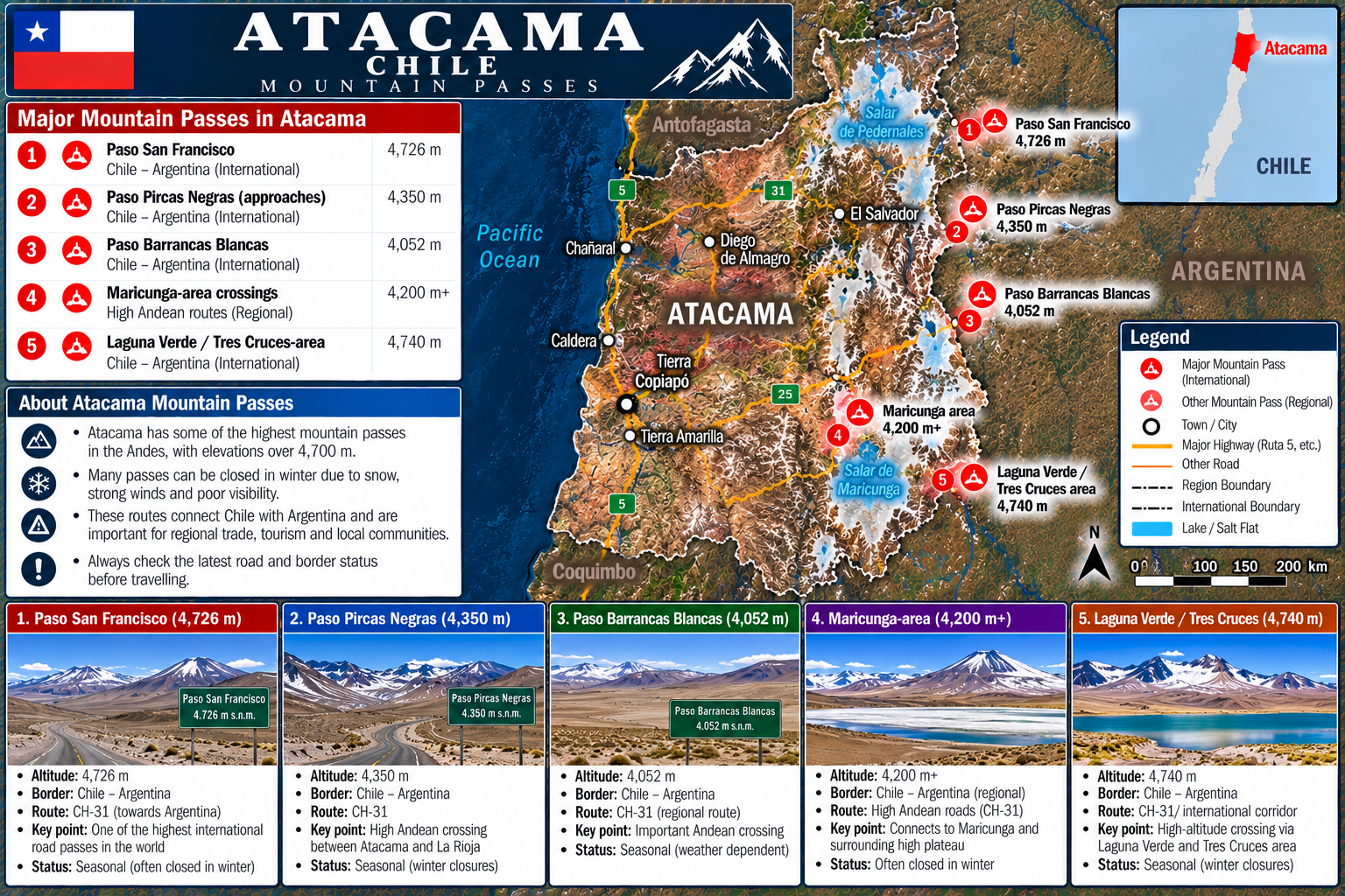
🇨🇱 Atacama Mountain Passes & Chile – Argentina Border Status
Live high Andean road conditions, border crossing operating hours, snowdrifts, hurricane-force wind reports, webcams, and altitude alerts across Ruta CH-31, Paso San Francisco (4,726 m), Paso Pircas Negras (4,350 m), Salar de Maricunga, and Laguna Verde / Nevado Tres Cruces. Sourced live from Pasos Fronterizos Chile (UPF / MOP) and Gendarmería Nacional Argentina.
Interactive geographical map showing major international passes, regional high Andean routes, salt flats, and highway corridors.
Atacama Mountain Passes Monitored: ① Paso San Francisco (4,726 m) • ② Paso Pircas Negras (4,350 m) • ③ Paso Barrancas Blancas (4,052 m) • ④ Maricunga-area (4,200 m+) • ⑤ Laguna Verde / Tres Cruces (4,740 m).Elevation Range: 4,052 m – 4,740 m (High Puna / Continental Divide)
Atacama Mountain Passes Live Status & Road Reports
Select any mountain pass card below to open detailed road conditions, winter closures, border customs hours, and webcam telemetry.
1 Paso San Francisco
Ruta CH-31 (Chile) • RN 60 (Argentina)
• SEASONAL OPEN
Altitude4,726 m (15,505 ft)
Border ConnectionChile ⇄ Argentina
Road SurfacePaved Highway (both sides)
Winter RiskViento Blanco / Heavy Snow
One of the highest international paved mountain passes in the world, connecting Copiapó in Atacama with Fiambalá and Tinogasta in Catamarca across the high Andes Continental Divide. Subject to sudden high-altitude snowstorms, gale-force winds, and winter closures.
2 Paso Pircas Negras
Quebrada Montosa (Chile) • RN 76 (Argentina)
• SEASONAL (SUMMER)
Altitude4,350 m (14,271 ft)
Border ConnectionAtacama ⇄ La Rioja
Road SurfaceUnpaved Gravel (4WD Required)
Operating SeasonDec / Jan to April only
Spectacular and remote trans-Andean route connecting Tierra Amarilla and Copiapó with Jagüé, Laguna Brava, and Vinchina in La Rioja, Argentina. High-altitude unpaved track strictly operational during summer months; closed in winter due to snowpacks and river washouts.
3 Paso Barrancas Blancas
Ruta CH-31 • Intermediate Andean Pass
• OPEN / PASSABLE
Altitude4,052 m (13,294 ft)
RoleIntermediate Frontier Post
Road SurfacePaved Highway
Condition AlertSub-Zero Night Ice & Wind
Crucial intermediate high-altitude mountain pass and Chilean border outpost on Ruta CH-31 located between Salar de Maricunga and the international summit of Paso San Francisco. Houses advance Carabineros and border coordination checkpoints.
4 Maricunga-Area Crossings
Ruta CH-31 & C-601 • Salar de Maricunga Plateau
• OPEN WITH CAUTION
Altitude4,200 m+ (13,780 ft)
RegionPuna de Atacama Salt Flat
Traffic TypeMining Freight & International
Weather HazardBlowing Salt Dust & Freezing Temps
High Andean plateau routes traversing the glittering Salar de Maricunga salt flat, bounded by Volcán Copiapó and Parque Nacional Nevado Tres Cruces. Essential transit artery for lithium, boron, and gold mining operations; frequently subject to sub-zero night freezes and sudden altiplanic storms.
5 Laguna Verde / Tres Cruces
Ruta CH-31 • International Corridor & Hot Springs
• CAUTION / HIGH WINDS
Altitude4,740 m (15,551 ft)
LandmarksOjos del Salado • Laguna Verde
SurfacePaved Highway & 4WD Trails
Wind AlertGusts >100 km/h (Gale Force)
Magnificent high-altitude Andean crossing situated alongside the hypersaline turquoise waters of Laguna Verde (4,350 m) and surrounding passes up to 4,740 m. Serves as base camp access for Nevado Ojos del Salado (6,893 m). Extreme wind conditions, sub-zero temperatures, and severe altitude sickness hazards.
The Región de Atacama in northern Chile contains some of the highest, most dramatically isolated, and treacherous highway passes anywhere in the Andes mountain range. Soaring beyond 4,700 meters (15,400+ feet) above sea level, these trans-Andean corridors connect Chilean Pacific coastal trade and mining hubs—including Copiapó, Caldera, Chañaral, and Diego de Almagro—with the Argentine provinces of Catamarca and La Rioja. Traversing this high desert plateau, known as the Puna de Atacama, demands thorough preparation, continuous monitoring of weather webcams, and an understanding of seasonal border closures.
⚠️ Critical Driver Advisory: Extreme High Altitude & No Fuel for 470 km
There are zero fuel stations, mechanics, or grocery stores between the outskirts of Copiapó in Chile and the town of Fiambalá in Catamarca, Argentina. This remote desert stretch spans over 470 kilometers across uninhabited high Andean terrain with temperatures routinely plunging below -20°C (-4°F). All vehicles must carry full reserves of fuel, anti-freeze rated for extreme sub-zero conditions, high-calorie food, multiple gallons of drinking water, and portable satellite or VHF emergency communications.
Paso San Francisco: Live Road Conditions, Border Status & Argentine Corridor (Ruta CH-31 / RN 60)
Rising to an astounding 4,726 meters (15,505 feet), Paso San Francisco (also known as Paso Internacional San Francisco) is universally recognized as one of the world's highest paved international border crossings. Connecting Chile's Ruta CH-31 with Argentina's Ruta Nacional 60 (RN 60), the pass traverses the Continental Divide between Copiapó and Fiambalá.
The highway is fully paved with modern asphalt on both the Chilean and Argentine sides, making it an extraordinary engineering feat. However, its immense altitude subjects it to relentless environmental hazards:
Border Hours & Coordination: Chilean immigration and customs are processed at the Complejo Fronterizo San Francisco (located near Salar de Maricunga and Barrancas Blancas), while the Argentine border complex operates at Las Grutas (RN 60, km 1420). The border typically operates daily from 09:00 to 17:00 hrs during open seasons.
Winter Closures: From late May through October, massive snowfall, sub-zero blizzards, and black ice force seasonal closures. Even in spring and summer, abrupt storms known as viento blanco can temporarily close the pass with zero notice.
Wind & Gale Conditions: Crosswinds exceeding 100 km/h (62 mph) frequently sweep the pass summit, causing wind deflection hazards for high-profile RVs, trucks, and motorcyclists.
Paso Pircas Negras: High-Altitude Crossing Between Atacama and La Rioja (4,350 m)
Paso Pircas Negras (4,350 m / 14,271 ft) connects Tierra Amarilla and Copiapó in Chile directly with the Argentine province of La Rioja, terminating on Ruta Nacional 76 (RN 76) near Jagüé, Vinchina, and the breathtaking Reserva Provincial Laguna Brava.
Unlike Paso San Francisco, Pircas Negras remains an unpaved high-desert mountain track through the Quebrada Montosa and Río Pulido. It is strictly a seasonal summer pass, normally opened by border authorities only between late December or January and mid-April. High-clearance 4WD vehicles are strictly mandatory due to steep rocky inclines, corrugations, sand traps, and river crossings.
Positioned along Ruta CH-31 approximately 200 km east of Copiapó, Paso Barrancas Blancas serves as the strategic transition zone between the Salar de Maricunga basin and the high ascent toward the international divide at San Francisco. Housing an advance Carabineros de Chile post and emergency shelter refugios, Barrancas Blancas is where road maintenance crews assess tire chain requirements and inspect vehicle readiness before drivers proceed toward the 4,726 m summit.
Salar de Maricunga: High Plateau Roads & Heavy Mining Logistics (4,200 m+)
The Salar de Maricunga is a vast, shimmering salt flat spanning dozens of kilometers across the high Puna at elevations exceeding 4,200 meters. The main highway CH-31 skirts the southern edge of the salar, carrying substantial heavy logistics traffic to regional mining installations including Maricunga, Caserones, and La Coipa, as well as accessing Parque Nacional Nevado Tres Cruces.
Road conditions across the Maricunga plateau are characterized by intense sunlight reflection off white salt crusts, violent thermal dust devils, and severe overnight temperature inversions. Road surfaces can freeze instantly when meltwater from surrounding snowfields runs across the tarmac at sundown.
Laguna Verde & Nevado Tres Cruces: 4,740 m Altitude & Thermal Waters
Tucked beneath the colossal volcanic cones of Nevado Tres Cruces (6,749 m) and Ojos del Salado (6,893 m, the world's highest active volcano) lies the hypersaline wonder of Laguna Verde. Surrounding mountain passes reach 4,740 meters, where geothermal hot springs bubble out along the emerald shoreline.
Travelers visiting Laguna Verde or crossing into Argentina via this corridor must anticipate extreme atmospheric pressure reductions (approximately 55% of sea-level oxygen). Acute Mountain Sickness (soroche) is common; visitors must hydrate constantly, avoid strenuous overexertion, and carry supplemental oxygen if planning high-altitude hikes.
Paso San Francisco Webcams & Real-Time Telemetry
Drivers can verify current road passability and atmospheric conditions through live meteorological sensors and camera installations maintained by the Unidad de Pasos Fronterizos (UPF) of Chile's Ministry of the Interior and Vialidad Nacional Argentina at Las Grutas. Before departing Copiapó, travelers are urged to verify the daily morning pass dispatch (Reporte Matutino de Pasos Fronterizos) issued at 08:00 hrs.
Authoritative answers to the most common queries regarding road conditions, border protocols, weather, and driving requirements.
Paso San Francisco (4,726 m) operates on a seasonal and coordinated schedule between Chile's Unidad de Pasos Fronterizos (UPF) and Argentina's Gendarmería Nacional. During spring and summer (November to April/May), it is generally open during daytime hours (typically 09:00 to 17:00 hrs), but daily closures can occur instantly if high Andean snowstorms or gale-force winds (viento blanco) develop. During winter (June to October), it is generally closed to regular traffic. Check the live status banner at the top of this page for today's active alert.
To cross between Chile and Argentina at Paso San Francisco, travelers require: (1) Valid Passport or National ID card (DNI / Cédula for Mercosur citizens); (2) Official vehicle registration certificate (Padrón); (3) Notarized authorization if the driver is not the registered owner; (4) Mandatory international auto insurance (SOAPEX for Chile / Seguro Mercosur RCI for Argentina); and (5) Completed customs declaration forms for SAG (Chilean Agriculture & Livestock Service) and AFIP/Aduana Argentina.
Official camera feeds, daily morning status reports, and road closure bulletins are published by Unidad de Pasos Fronterizos Chile (pasosfronterizos.gov.cl), Dirección de Vialidad MOP Región de Atacama, and Gendarmería Nacional Argentina at the Las Grutas control complex on RN 60.
Viento blanco (white wind) is a perilous Andean phenomenon where violent gale-force winds whip loose snow into a blinding blizzard, reducing visibility to zero within seconds. At 4,726 m, temperatures plunge below -25°C, causing frostbite and vehicle stalls. Snowplows cannot operate safely during active viento blanco storms, leading to road closures that can last several days.
Paso Pircas Negras (4,350 m) is open strictly during mid-summer months (December/January through April). The route consists of unpaved, sharp volcanic gravel, rocky dry riverbeds, and sand across Quebrada Montosa and RN 76. Standard passenger cars cannot safely traverse this route; high-clearance 4x4 vehicles equipped with heavy-duty all-terrain tires and two spare wheels are required.
The main corridor along Ruta CH-31 past Salar de Maricunga and Laguna Verde is paved and in good condition, but drivers must exercise caution regarding black ice (especially in shaded corners and around culverts) and intense crosswinds. Lateral access tracks leading to the shores of Laguna Verde and mountaineering refugios beneath Ojos del Salado are unpaved gravel and require 4WD vehicles.
Yes. Carabineros de Chile and Argentine Gendarmería officers enforce mandatory carrying of snow chains in all vehicles attempting to cross Paso San Francisco whenever snow, slush, or freezing rain is forecast. Failure to present functional tire chains at the Barrancas Blancas or Maricunga checkpoints will result in police turning your vehicle back.
Driving from sea level in Caldera or 400 m in Copiapó to over 4,726 m in a single day is a rapid elevation gain that frequently triggers acute altitude sickness (soroche). Travelers should: (1) Acclimatize by spending a night at intermediate altitudes (such as Maricunga at 4,000 m); (2) Drink plenty of water and avoid alcohol; (3) Eat light, high-carbohydrate meals; and (4) Descend immediately if severe symptoms like persistent vomiting, disorientation, or breathlessness at rest occur.
Official Monitoring Authorities & Emergency Contacts
Direct links to official government agencies providing authoritative pass status, weather forecasts, and border regulations for Atacama.
Unidad de Pasos Fronterizos (UPF)
Ministerio del Interior y Seguridad Pública • Chile