Arica y Parinacota Passes Live Status
Select any pass below for detailed road conditions, border customs hours, and altiplanic weather alerts.
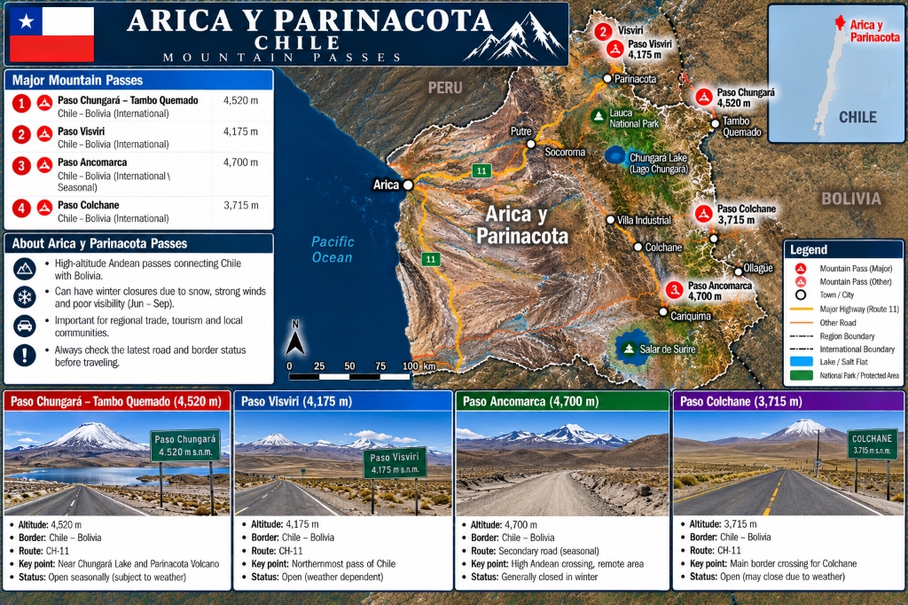
Paso Chungará – Tambo Quemado
Premier high-altitude international corridor connecting Arica with Tambo Quemado (Bolivia) through Lauca National Park near Chungará Lake & Parinacota Volcano. Open daily subject to altiplanic storms.
Paso Visviri
Northernmost international pass of Chile located near the tripartite border point of Chile, Peru, and Bolivia. Open daily for passenger traffic and local trade.
Paso Ancomarca
Extremely remote high Andean crossing at 4,700 m altitude. Unpaved secondary gravel road; generally closed or restricted during winter snowpack and heavy summer rains.
Paso Colchane – Pisiga
Major international commercial border pass connecting Iquique and Colchane with Pisiga and Oruro (Bolivia) across the high altiplano near Salar de Surire, Cariquima, and Volcán Isluga.
Cariquima & Volcán Isluga Route
Highland mountain pass route connecting the indigenous Aymara village of Cariquima and Parque Nacional Volcán Isluga with the Colchane – Pisiga international border corridor.
Arica y Parinacota Passes Overview Table
Quick reference for elevation, highway route, border crossing, and status.
| Pass / Route Name | Highway | Elevation | Border Crossing | Status | Road Surface & Restrictions |
|---|---|---|---|---|---|
| Paso Ancomarca | Secondary Road | 4,700 m | Chile – Bolivia | SEASONAL | Unpaved 4x4 gravel; closed in winter |
| Paso Chungará – Tambo Quemado | Ruta CH-11 | 4,520 m | Chile – Bolivia | OPEN | Paved highway; high altitude weather warnings |
| Paso Visviri | CH-11 Ext. | 4,175 m | Chile – Bolivia | OPEN | Northernmost pass of Chile; open daily |
| Cariquima & Volcán Isluga Route | Ruta A-55 / CH-15 | 3,850 m | Chile – Bolivia Access | OPEN | Highland altiplano road; open with weather caution |
| Paso Colchane – Pisiga | Ruta CH-15 | 3,715 m | Chile – Bolivia | OPEN | Paved commercial border corridor; open 24/7 |