Trøndelag Mountain Passes Live Status
Select any pass below for detailed road conditions, winter closure schedules, and mountain webcams.
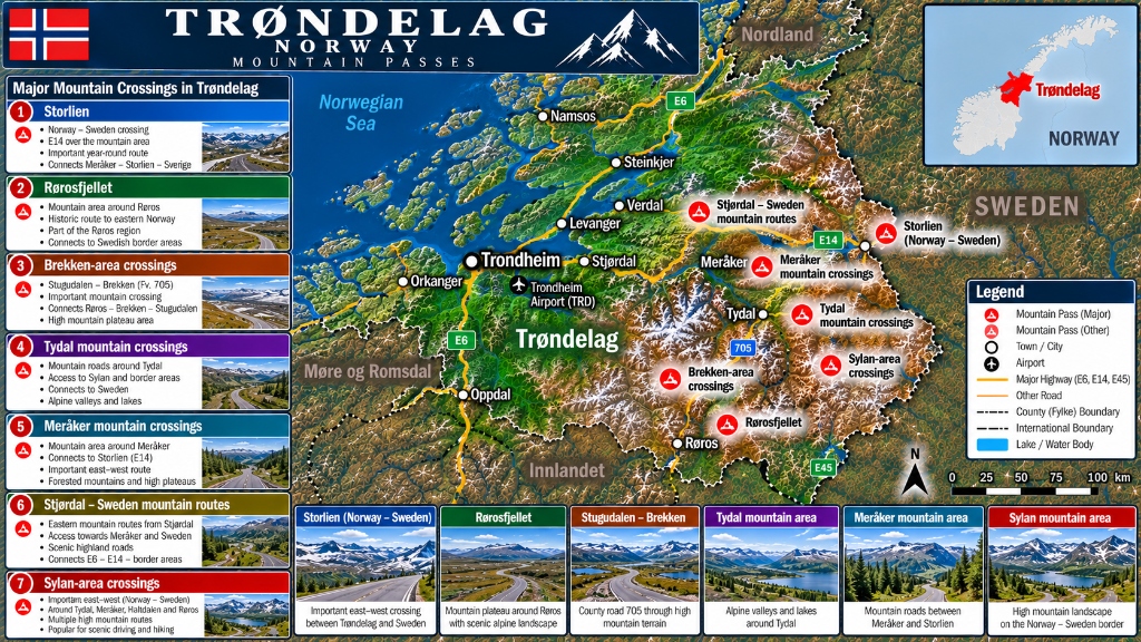
Storlien (Norway – Sweden Border)
Essential year-round international mountain crossing linking Stjørdal & Trondheim to Sweden (Åre). Continuous winter clearing; convoy driving during severe blizzards.
Rørosfjellet
High mountain plateau surrounding UNESCO World Heritage town Røros. Connects eastern Norway to Swedish border area. Sub-zero temperatures and drift snow in winter.
Stugudalen – Brekken
High mountain plateau road connecting Røros, Brekken, and Stugudalen. Exposed to wind drifts across open mountain tundra.
Tydal Mountain Area
High alpine valley and lake routes offering access to the Sylan mountain wilderness and Swedish border crossings.
Meråker Mountain Crossings
East-west mountain corridor surrounding Meråker leading to the Swedish frontier. Forested mountain terrain with high winter snowpack.
Stjørdal – Sweden Routes
Highland mountain road running east from Trondheim Airport (TRD) & Stjørdal toward the Swedish border highlands.
Sylan Area Crossings
High mountain wilderness routes encircling the Sylan mountain massif on the Norway-Sweden border. Popular for scenic alpine driving and hiking.
Trøndelag Passes Overview Table
Quick reference for elevation, highway designation, and current road status.
| Pass / Route Name | Highway | Elevation | Region | Status | Winter Mandates |
|---|---|---|---|---|---|
| Sylan Area Crossings | Border Routes | 1,100 m | Tydal / Sylan Massif | OPEN | Winter tires mandatory Oct 16–Apr 30 |
| Rørosfjellet | Fv30 / Fv705 | 900 m | Røros Plateau | OPEN | Extreme winter cold; winter tires mandatory |
| Stugudalen – Brekken | Fv705 | 850 m | Brekken / Tydal | OPEN | Exposed plateau drift snow risk |
| Tydal Mountain Area | Fv705 | 800 m | Tydal / Sylan | OPEN | Open year-round with snow clearing |
| Stjørdal – Sweden Routes | E14 | 700 m | Stjørdal / Meråker | OPEN | Year-round international E14 route |
| Storlien (Norway-Sweden) | E14 | 600 m | Meråker / Storlien | OPEN | Year-round international border pass |
| Meråker Mountain Crossings | E14 / Fv751 | 600 m | Meråker Valley | OPEN | Open year-round |